


You haven’t got any favourites yet
This is where you can collect inspiration, articles, events and places that interest you.
Click the icon on pages and they’ll appear here.
Your favourites
Inspiration & Articles
Events & Tours
Places
Hiking
INSPIRATION & ARTICLES
EVENTS & HIKES
Places
Syðrugøta - Ánir


Link Copied!

-
 The view from the gorge Gøtugjógv south over Heygarnir. In the background the pass Gøtueiði and the mountains Støðlafjall and Miðafelli. Photo: Óli Gardshodn.
 -
 The view just outside the village gate at the Gøtugjógv gorge. To the right is the village of Syðrugøta. Photo: Óli Gardshodn
 -
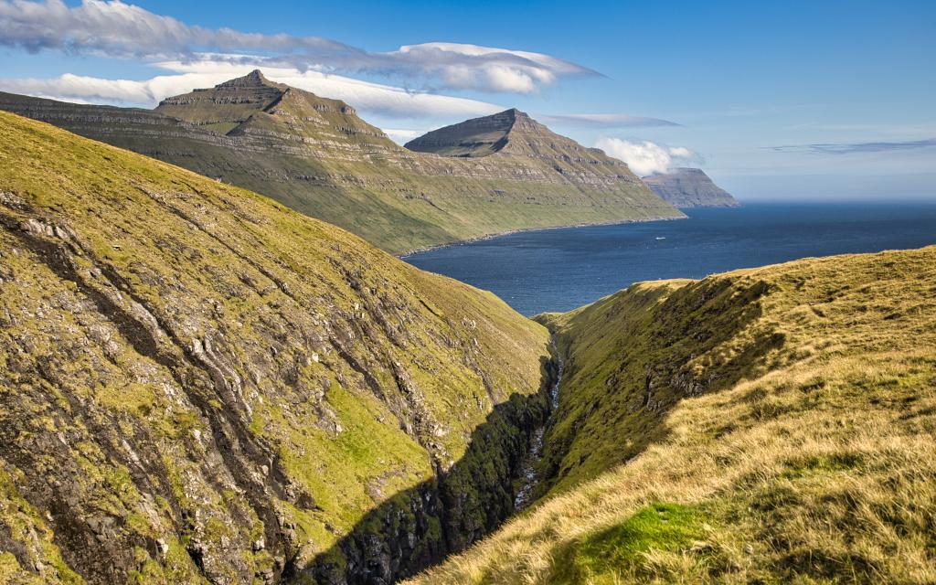 The view down the gorge Gøtugjógv and the bay Gøtuvík, with the mountains Sigatindur and Gøtunestindur. Behind Borðoyarnes. Photo: Óli Gardshodn
 -
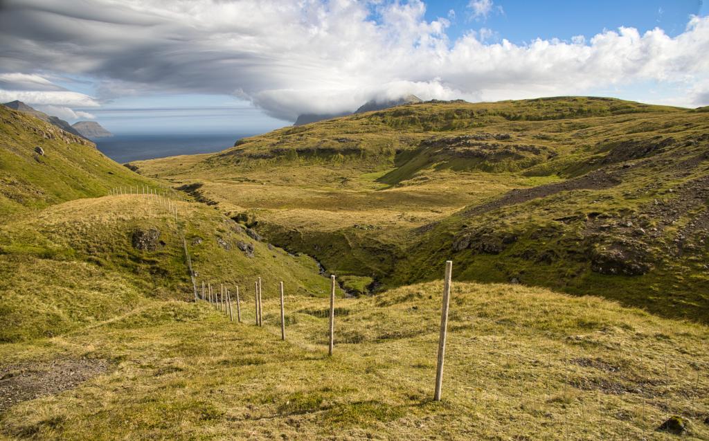 Up in the Gjódalur valley – above the Gøtugjógv gorge mouth. It's so cozy and peaceful here - a little pearl where the noise of everyday life doesn't reach. And it was precisely here that the farmhand had to make the famous jump across the stream. Photo: Óli Gardshodn.
 -
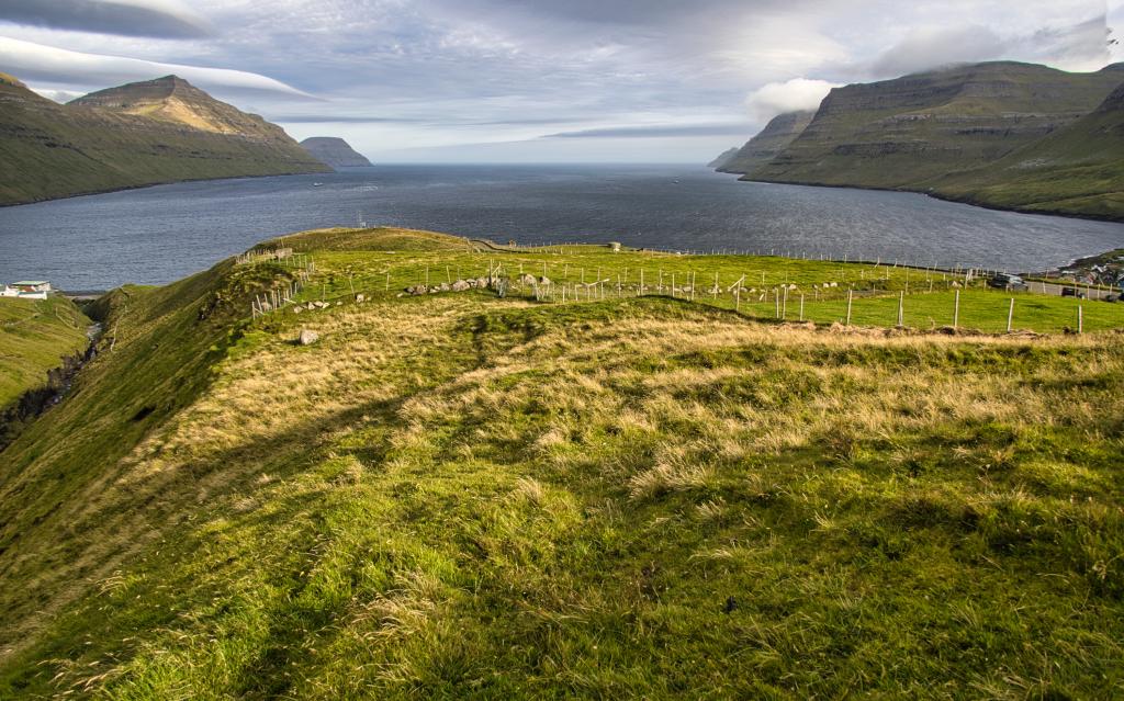
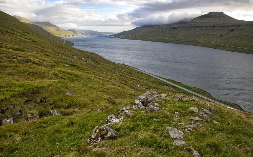 View up from Ánadali out towards the Skálafjørður fjord, where we see the village of Søldarfjørður on the far left. Up here in the valley, a lot of good turf was cut. On the steep stretch down to the beach, the peat was transported by zipline, from where the boats sailed it on, mostly to the settlement of Søldarfjørður. Photo: Óli Gardshodn
 -
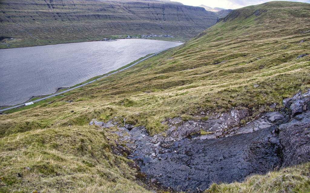 The view down over the lower part of the Ánadalur valley, where the peat sheds were located. At the end of the fjord you can see the village of Skálafjørður, from where the farmhand had to carry the barren ewe over the Gjógvhálsar pass to the so-called Húskallalopið. Photo: Óli Gardshodn
-
The view from the gorge Gøtugjógv south over Heygarnir. In the background the pass Gøtueiði and the mountains Støðlafjall and Miðafelli. Photo: Óli Gardshodn.
-
The view just outside the village gate at the Gøtugjógv gorge. To the right is the village of Syðrugøta. Photo: Óli Gardshodn
-
The view down the gorge Gøtugjógv and the bay Gøtuvík, with the mountains Sigatindur and Gøtunestindur. Behind Borðoyarnes. Photo: Óli Gardshodn
-
Up in the Gjódalur valley – above the Gøtugjógv gorge mouth. It's so cozy and peaceful here - a little pearl where the noise of everyday life doesn't reach. And it was precisely here that the farmhand had to make the famous jump across the stream. Photo: Óli Gardshodn.
-
View up from Ánadali out towards the Skálafjørður fjord, where we see the village of Søldarfjørður on the far left. Up here in the valley, a lot of good turf was cut. On the steep stretch down to the beach, the peat was transported by zipline, from where the boats sailed it on, mostly to the settlement of Søldarfjørður. Photo: Óli Gardshodn
-
The view down over the lower part of the Ánadalur valley, where the peat sheds were located. At the end of the fjord you can see the village of Skálafjørður, from where the farmhand had to carry the barren ewe over the Gjógvhálsar pass to the so-called Húskallalopið. Photo: Óli Gardshodn
Syðrugøta - Ánir offers a scenic 4 km hike along the Gøtugjógv gorge to historic turf ruins in Ánadalur.
In the upper reaches of Kinnarvegur Road, above the village of Syðrugøta, you will find a small road leading out to the outfields gate, close to a gorge. From there, go west alongside the gorge. Though easy to spot in places, the path can be hard, even impossible to see. This path, running alongside the gorge Gøtugjógv, through the valley Gjódalur and over the pass Gjógvhálsar, is the old way to the outfields called norður í Haga. The path was also used to reach the peatland in Gjódalur as well as the villages to the north.
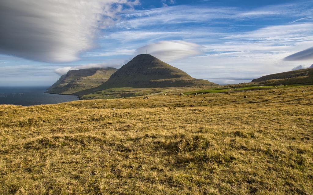
As you hike up the hill, you have wonderful views into the deep, beautiful and impressive gorge Gøtugjógv, which is part of a fissure that divides the country into two, from Gøtugjógv to the village of Saksun, Streymoy.
Hike up along the length of the gorge until you reach its upper end. From here, go north, cross the river and hike the last stretch up through Gjódalur, alongside the gully Elspugil, and continue up to Gjógvhálsar (alt. 278 m.), which is the highest point of the path. You cross the river at a place called Húskallalopið (The Farmhand Leap). The story goes that in order to become a farmhand in the farm niðri við Hús in Syðrugøta, you had to be able to carry a wether all the way from the sheepfold by the estuary in the village of Skálafjørður, up over the pass Gjógvhálsar, and then jump across the river by the hollow Gjómunna (just above the gorge Gøtugjógv) without taking a break. Quite the feat!
From Gjógvhálsar there are good views through the fiord Skálafjørður to the mountains in the north, the northernmost being Mt. Svarbakstindur; with its 801 metres, it is the tenth highest peak in the Faroes. Here you also see the gorges Øksnagjógv and Lokkafelsgjógv, which are part of the fissure mentioned above, which divides both the island of Eysturoy and Streymoy into two. Immediately north of you, you look down over the valley Ánadalur, where much peat used to be cut. Just above Ánadalur you will find the pass Trælavatnaskarð, where the village path from Kambsdalur leads up to.
From Gjógvhálsar, angle down toward the terrace Hvíthjalli by Ánir. At Hvíthjalli, at an elevation of about 100 metres, just south of the river Norðastuá, the path merges with the path coming down from Trælavatnaskarð. Follow the path straight down to the main road.
As mentioned earlier, much peat was cut in Ánadalur. It was cut by villagers from Søldarfjørður. The peat was taken down to Hvíthjalli with a telpher, and from there down to the beach Ánasandur using another telpher. From there it was taken to the village by rowing boats. The many peat store ruins at Hvíthjalli testify to the peat that once was cut there.
Many stories are told about the brazen sheep thieves in the outfields called norðuri í Haga. One story is about the notoriously quick farmhand Jákup Dintil. He had gone to norðuri í Haga to tend to the sheep. As it was too late to walk the long way back home to Syðrugøta, he went into a sheep shed in norðuri í Haga, where people also could spend the night. Here he made himself comfortable on top of the sheep skins stretched out across the roof beams. Later, two sheep thieves suddenly entered the shed to slaughter a stolen sheep each and cook themselves a meal. As they sat eating, Jákup Dintil cut the rope holding the pot in such a way that the pot spilled over the thieves. Then he threw the skin over the men, jumped on them, trampled them and fled. Being fast, he outran them and sped home to Syðrugøta to tell the farmer, who rewarded him richly for the feat.
It was also in these wide fields between Funningsfjørður and Skálafjørður, called Millum Fjarða, that men often got lost and died when drunk. Therefore, according to legend, Mikkjal, the sheriff of Eysturoy, initiated a new settlement in Skálafjørður. This made it also far easier to cut peat, because now they could transport it with a horse-drawn carriage that they borrowed in Skálafjørður.


Syðrugøta - Ánir
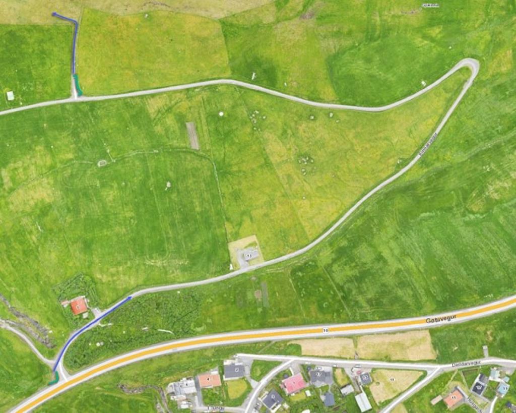
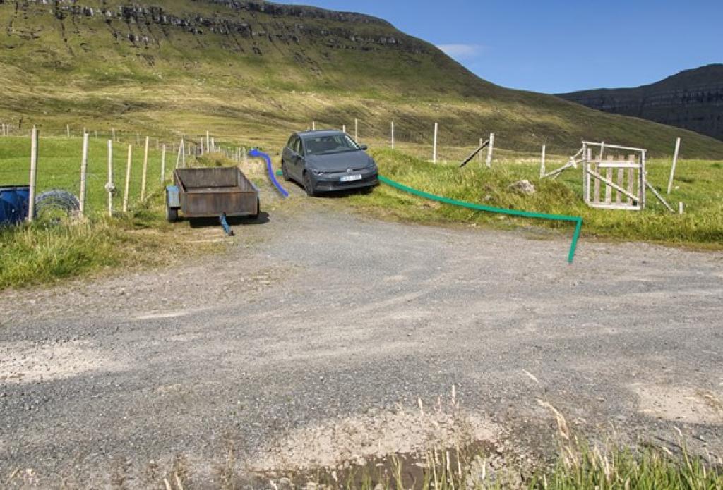
The hike starts 800 metres from the road Kinnarvegi. The sideroad to the fence is small, but there is room for 1-2 cars depending on how they're parked. See the green lines on the photos. Follow the blue line from here.
Ánir - Syðrugøta
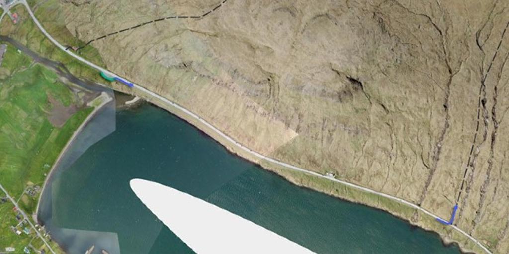
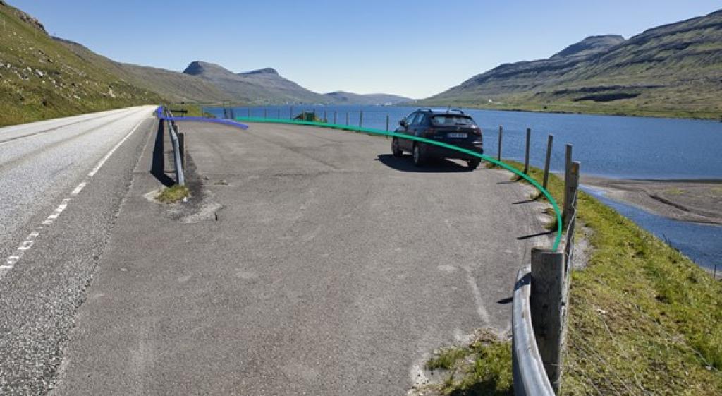
There is no parking in Ánir. You can park 1,3 km north of the starting point, along the main road - see green line on photos. Walk from here to where the hike starts - see blue arrows.
Syðrugøta - Ánir
Ánir - Syðrugøta
Facts

Duration

distance

Peak

Elevation
 Yes, 8+
 Medium
-
Medium
-
 Grassy path, but a little steep above Ánir. Can be slippery when wet.
